Thunderstorm in Northern India Claims Lives Amidst Unusual Weather Patterns
A severe thunderstorm in northern India resulted in at least 59 deaths, attributed to unusual weather patterns, including persistent Western Disturbances linked to Arctic warming. Meteorologists indicate this atmospheric complexity has disrupted typical monsoon progression. The storm caused extensive damage, particularly in Uttar Pradesh, and led to significant disruptions in Delhi, with further weather disturbances expected in the coming days.
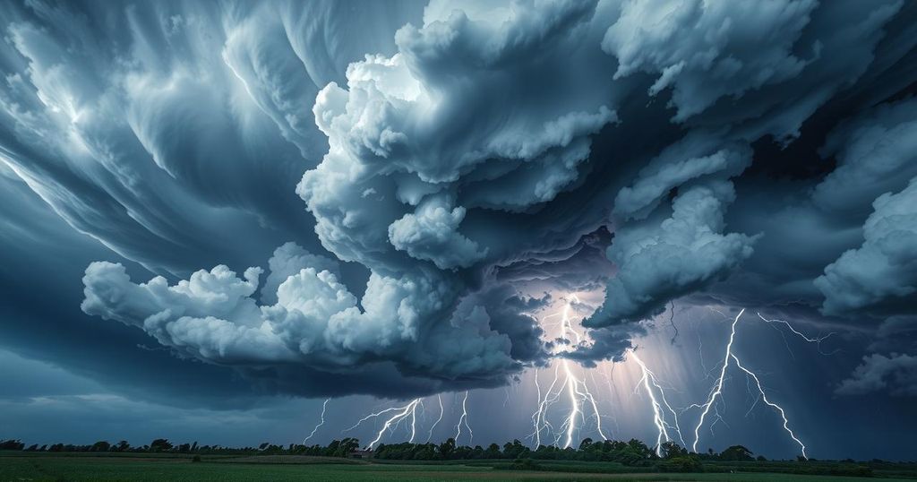
On Wednesday, a powerful thunderstorm resulted in at least 59 fatalities across two states in northern India, as officials confirmed on Thursday. The storm was tied to unusual atmospheric conditions, including a combination of cyclonic activity, abundant moisture from two temperate seas flanking the subcontinent, and extreme daytime heating. Adding to the severity, persistent winter systems known as Western Disturbances, typically diminishing by now, have had an unanticipated extended presence.
Meteorologists have indicated that this atmospheric cocktail is a result of shifts occurring far beyond Indian borders—specifically, record heat in the Arctic Circle that is enabling cold air to flow southward. This phenomenon might very well be contributing to unseasonable cool spells in regions as diverse as the US Eastern Seaboard. The current weather disruption in India mirrors troubling shifts seen elsewhere in global weather patterns.
M. Rajeevan, former secretary of the Ministry of Earth Sciences, explained that Western Disturbances, which generally affect India during winter months before shifting northward in summer, have lingered unusually late into the warmer season. “Western Disturbances are expected to retreat northward around April, May, and June. However, their effects have continued this summer, which poses challenges for the monsoon,” he stated.
Rajeevan further noted that emerging studies indicate a trend where the season for active Western Disturbances might be shifting. This change could correlate to reduced Arctic sea ice, which has been shown to impact mid-latitude weather systems and induce extremes in the Indian monsoon. While severe weather in India appears to be increasingly influenced by Arctic warming, the storm’s immediate genesis was very much a local affair due to atmospheric instability.
The tornado’s ferocity was enhanced by a cyclonic circulation affecting northern India, combined with moisture from both the Bay of Bengal and the Arabian Sea. “The instability leads to conditions resembling bubbles, resulting in significant rain and thunderstorms,” said Rajeevan. Notably, the close monitoring of whether this pattern will affect monsoon progression is crucial, as the ongoing patterns may complicate the seasonal norm.
Officials from the India Meteorological Department (IMD) noted that there was no active Western Disturbance affecting northwest India on the day of the storms. Yet, Mahesh Palawat, vice president at Skymet, shed light on the matter, suggesting that those cyclonic circulations are indeed connected to mild Western Disturbances observed in the region. He pointed out that a cyclonic circulation over southern Punjab is expected to cause dust storms and thunderstorms lasting through the end of May.
Uttar Pradesh, particularly West UP, faced the harshest impacts from the storm. Tragic incidents, including multiple deaths from lightning strikes and collapsing structures, heightened the toll. A 65-year-old man in Saharanpur, a six-year-old girl in Sonbhadra, and many others were among the casualties, with structural collapses causing further loss of life.
In the capital, Delhi, the storm brought dramatic weather changes; gusts soared as high as 79 km/hr at Safdarjung. Temperatures plummeted from 37°C to 23°C within just one hour at Palam Airport. The storm caused extensive disruption, including flight diversions and delays at Indira Gandhi International Airport and impacted the metro services across multiple lines.
Looking ahead, a low-pressure system over the east-central Arabian Sea is projected to evolve into a depression by Friday evening, possibly marking an early onset of the monsoon in Kerala, expected a few days prior to the customary June 1 schedule. However, Rajeevan cautioned that continued interference from Western Disturbances could complicate monsoon conditions across the region.
Ultimately, this intense storm serves as a powerful reminder that climate change, coupled with perturbations occurring thousands of kilometres away, can have significant consequences for India’s weather patterns, particularly concerning agriculture and urban infrastructure. The unexpected climatic shifts, influenced by the Arctic’s extreme changes, might be molding the nation’s environmental landscape in ways that are just beginning to unfold.
The deadly thunderstorms on Wednesday, which claimed 59 lives in northern India, underscore the complex interplay of weather patterns influenced by both local and distant atmospheric conditions. The persistence of Western Disturbances, combined with Arctic warming, poses significant risks for the upcoming monsoon season. As meteorologists analyze these unprecedented disruptions, severe implications for agriculture and infrastructure loom, highlighting the necessity for ongoing monitoring of weather trends.
Original Source: www.hindustantimes.com


