Dwindling Odds for October Atlantic Named Storms Amid Cyclonic Activity
As October progresses, the chances for new named storms in the Atlantic are decreasing, with Hurricane Milton possibly being the last named storm for the month. Tropical disturbances, including Invest 94L, face significant development challenges. Meanwhile, the North Indian Ocean cyclone season may see new activity in the coming week, with conditions favorable for storms.
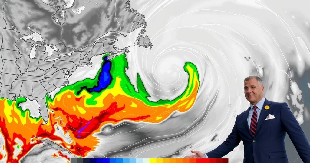
As October progresses, the Atlantic tropics have experienced a period of decreased activity after an early burst of storms. Currently, two tropical disturbances are being monitored, although their chances of evolving into named storms appear low. It is anticipated that Hurricane Milton might conclude the month’s list of named storms. However, with the arrival of the Madden-Julian Oscillation (MJO) in early November, which typically promotes upward air movement conducive to tropical cyclone formation, the fate of the hurricane season remains uncertain. Invest 94L, a disturbance approaching the northern Leeward Islands, is moving westward at approximately 20 miles per hour. Despite the presence of warm ocean temperatures reaching up to 30 degrees Celsius (86°F) and minimal wind shear that typically favor storm development, 94L is encountering a dry atmospheric layer, limiting significant thunderstorm activity. Its rapid movement also complicates its ability to synchronize its upper-level and surface centers, thereby inhibiting development. Forecast models indicate that 94L will face considerable challenges including strong wind shear if it ventures towards Florida or mountainous terrain over Hispaniola if it moves west-southwest. Most models predict little to no further development of this disturbance, with many projecting its decline by Sunday. Nonetheless, it is expected to bring heavy rainfall to the Leeward Islands, Virgin Islands, Puerto Rico, and the Dominican Republic from Friday through Saturday, potentially resulting in one to two inches (25-50 mm) of rain. As of the latest National Hurricane Center’s advisories, the odds of 94L developing are rated at 20% over two days and 30% over the next week. In addition, a disturbance related to the Central American Gyre, located off the northeastern coast of Honduras, poses a minimal chance of developing into a tropical cyclone before making landfall this weekend, although substantial rainfall is likely. This system is expected to bring significant amounts of rainfall, exacerbating flood risks in southern Mexico, Belize, Guatemala, and Honduras. Meanwhile, as the North Indian Ocean enters its secondary cyclone season, predictions indicate a likely formation of a tropical cyclone in the eastern Bay of Bengal next week, supported by favorable conditions from the MJO. Past occurrences, such as Cyclone Mocha in May 2023, highlight the potential destructive impact of such storms, having inflicted significant casualties and monetary damages. The ongoing civil conflict in Myanmar further complicates evaluations of cyclone impact, obscuring the true toll taken by such disasters.
In the tropical Atlantic, the hurricane season typically spans from June to November, with October often witnessing peak storm activity. This season, however, has shown a varied level of activity. The Madden-Julian Oscillation (MJO) is a critical factor in tropical cyclone formation, influencing atmospheric conditions significantly. In addition, the North Indian Ocean has two main cyclone seasons, with one occurring post-monsoon in October and November. Understanding the dynamics of these meteorological phenomena is essential for predicting storm development and assessing risks posed by tropical disturbances.
The likelihood of another named storm forming in the Atlantic is diminishing as we approach the end of October. While certain disturbances, such as Invest 94L, may not develop into named storms due to unfavorable conditions, the arrival of the Madden-Julian Oscillation could revitalize storm potential in coming weeks. Additionally, the ongoing situation in the North Indian Ocean underscores the potential for significant storm activity as the cyclone season unfolds. Continuous monitoring and preparedness are advised as these systems develop.
Original Source: yaleclimateconnections.org


