Forecast Update: Potential Storm Development in the Gulf of Mexico
The National Hurricane Center has predicted a 50% chance of a tropical depression forming in the Gulf this week. This follows Hurricane Helene and involves monitoring of Hurricane Isaac and Tropical Storm Joyce, which are not expected to impact the U.S. Additionally, increased storm activity is projected for the remainder of the hurricane season.
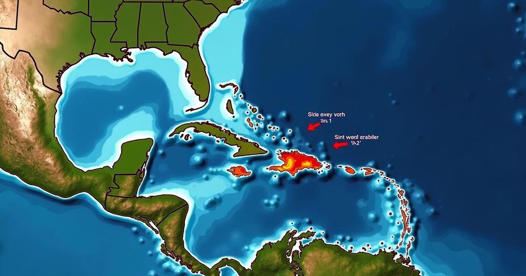
In light of recent meteorological developments, the U.S. Gulf Coast and Caribbean regions are advised to remain vigilant for a new weather system that may emerge later this week. As per the National Hurricane Center’s latest updates issued on Sunday morning, there exists a potential for the formation of a tropical depression in the western Caribbean Sea, which is expected to traverse into the Gulf of Mexico. Current assessments indicate that this system has approximately a 50% likelihood of evolving into either a tropical depression or a storm within the upcoming seven days. Should this system materialize, it is anticipated to be designated as either Kirk or Leslie, the subsequent names scheduled for the 2024 storm season. Moreover, the National Hurricane Center (NHC) is closely observing Hurricane Isaac, which is currently situated several hundred miles northwest of the Azores in the North Atlantic Ocean. Isaac is presently categorized as a Category 1 hurricane with sustained winds around 80 mph. Concurrently, Tropical Storm Joyce is positioned over the North Atlantic Ocean, roughly 1,000 miles east of the Northern Leeward Islands, with expectations of being classified as a tropical storm by Monday. Neither Joyce nor Isaac are projected to make landfall in the United States. In addition, an area of low pressure developing in the eastern Atlantic near Cabo Verde is reported to have an 80% chance of forming over the next week, with a 60% probability in the next two days. Meteorologists are also evaluating a tropical wave near the western coast of Africa that has the potential to develop further as it continues its westward or west-northwestward trajectory over the coming week. As of the last report, the likelihood of this system developing within the next week remains low. This year, the National Oceanic and Atmospheric Administration (NOAA) projected an unprecedented total of 17 to 25 named storms for the Atlantic, indicating a considerably intense storm season. Following a mid-season lull, forecasters have warned that an upswing in tropical activity is anticipated as the season progresses. It is pertinent to note that hurricane season will conclude on November 30th.
The Atlantic hurricane season, which officially begins on June 1 and continues until November 30, is a critical period for weather forecasting and preparedness along coastal regions, particularly in the Gulf of Mexico and the Caribbean. The susceptibility of these areas to tropical storms and hurricanes necessitates continuous monitoring by organizations such as the National Hurricane Center. In recent updates, meteorologists have predicted increased storm activity, reinforcing the importance of public awareness and preparedness in the face of potential natural disasters. As climate patterns evolve, the upcoming weeks are crucial for citizens residing in vulnerable areas to stay informed. This year’s hurricane forecast suggests an atypical level of storms, underlining the need for heightened vigilance during the latter part of the season.
In conclusion, the National Hurricane Center has issued updates indicating a 50% chance for a developing tropical depression in the Gulf Coast and Caribbean region, projected to evolve into a potential storm named Kirk or Leslie. Concurrently, Hurricane Isaac and Tropical Storm Joyce are being monitored, neither of which is expected to affect the U.S. Further, a low-pressure area in the eastern Atlantic presents an 80% chance of development. With the NOAA forecasting an unusually active hurricane season, it is imperative for residents in affected areas to stay informed throughout this period.
Original Source: www.nola.com


